Saylorsburg, Pennsylvania: Difference between revisions
Content deleted Content added
Added historical population, infobox (via CenPop script) Tag: Reverted |
Modified historical population, infobox (via CenPop script) Tag: Reverted |
||
| Line 39: | Line 39: | ||
<!-- Area --> |
<!-- Area --> |
||
|unit_pref = Imperial |
|unit_pref = Imperial |
||
|area_footnotes = <ref name="TigerWebMapServer">{{cite web|title=ArcGIS REST Services Directory|url=https://tigerweb.geo.census.gov/arcgis/rest/services/TIGERweb/Places_CouSub_ConCity_SubMCD/MapServer/5/query?where=STATE='42'&outFields=NAME,STATE,PLACE,AREALAND,AREAWATER,LSADC,CENTLAT,CENTLON&orderByFields=PLACE&returnGeometry=false&returnTrueCurves=false&f=json|publisher=United States Census Bureau|accessdate=October |
|area_footnotes = <ref name="TigerWebMapServer">{{cite web|title=ArcGIS REST Services Directory|url=https://tigerweb.geo.census.gov/arcgis/rest/services/TIGERweb/Places_CouSub_ConCity_SubMCD/MapServer/5/query?where=STATE='42'&outFields=NAME,STATE,PLACE,AREALAND,AREAWATER,LSADC,CENTLAT,CENTLON&orderByFields=PLACE&returnGeometry=false&returnTrueCurves=false&f=json|publisher=United States Census Bureau|accessdate=October 15, 2022}}</ref> |
||
|area_magnitude = |
|area_magnitude = |
||
|area_total_km2 = 3.28 |
|area_total_km2 = 3.28 |
||
| Line 85: | Line 85: | ||
{{US Census population |
{{US Census population |
||
|2020= 1025 |
|2020= 1025 |
||
|footnote=U.S. Decennial Census<ref name="DecennialCensus">{{cite web|url=http://www.census.gov/prod/www/decennial.html|title=Census of Population and Housing|publisher=Census.gov|accessdate=June 4, 2016}}</ref> |
|footnote=U.S. Decennial Census<ref name="DecennialCensus">{{cite web|url=http://www.census.gov/prod/www/decennial.html|title=Census of Population and Housing|publisher=Census.gov|accessdate=June 4, 2016}}</ref><ref name="USCensusDecennial2020CenPopScriptOnly">{{cite web|url=https://api.census.gov/data/2020/dec/pl?get=P1_001N,NAME&for=place:*&in=state:42&key=5ccd0821c15d9f4520e2dcc0f8d92b2ec9336108|title=Census Population API|publisher=United States Census Bureau|accessdate=Oct 15, 2022}}</ref> |
||
}} |
}} |
||
==Notable person== |
==Notable person== |
||
Revision as of 12:57, 15 October 2022
Saylorsburg, Pennsylvania | |
|---|---|
Census-designated place | |
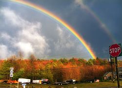
 Rainbow near PA 33 | |
| Coordinates: 40°53′44″N 75°19′25″W / 40.89556°N 75.32361°W | |
| Country | United States |
| State | Pennsylvania |
| County | Monroe |
| Township | Hamilton, Ross |
| Area | |
| • Total | 1.26 sq mi (3.28 km2) |
| • Land | 1.21 sq mi (3.12 km2) |
| • Water | 0.06 sq mi (0.15 km2) |
| Elevation | 669 ft (204 m) |
| Population | |
| • Total | 1,025 |
| • Density | 849.92/sq mi (328.29/km2) |
| Time zone | UTC-5 (Eastern (EST)) |
| • Summer (DST) | UTC-4 (EDT) |
| ZIP code | 18353 |
| Area code(s) | 570 and 272 |
| GNIS feature ID | 1187049[3] |
Saylorsburg is a census-designated place and unincorporated community in Monroe County, Pennsylvania, United States. Saylorsburg is located off Pennsylvania Route 33, 5 miles (8.0 km) northwest of Wind Gap. As of the 2010 census, its population was 1,126.[4] The village is located in both Ross Township and Hamilton Township.
Saylorsburg is in the Pocono Mountains.[5]
One of the two main centers of Arsha Vidya Gurukulam is located here. This is a Hindu Vedic teaching center founded by Swami Dayananda Saraswati.
Demographics
| Census | Pop. | Note | %± |
|---|---|---|---|
| 2020 | 1,025 | — | |
| U.S. Decennial Census[6][2] | |||
Notable person
- Fethullah Gülen - founder of the Gülen movement, resides here.
References
- ^ "ArcGIS REST Services Directory". United States Census Bureau. Retrieved October 15, 2022.
- ^ a b "Census Population API". United States Census Bureau. Retrieved Oct 12, 2022. Cite error: The named reference "USCensusDecennial2020CenPopScriptOnly" was defined multiple times with different content (see the help page).
- ^ "Saylorsburg". Geographic Names Information System. United States Geological Survey, United States Department of the Interior.
- ^ "U.S. Census website". United States Census Bureau. Retrieved 2011-05-14.
- ^ Carl S. Oplinger & Robert Halma, The Poconos: An Illustrated Natural History Guide (Rutgers University Press: 1988), p. 44.
- ^ "Census of Population and Housing". Census.gov. Retrieved June 4, 2016.


